Gavin O’Connor trawls through Twitter and finds out what people were saying and what photos they were posting on Garvey’s Supervalu Kerry SFC Final day…
There were signs early on that we were in for a good day when Dermot Mahony spotted this rainbow over Austin Stack Park.
Rainbow in Tralee for game pic.twitter.com/GtMqc5pBEp
— Dermot Mahony (@micko14900) October 26, 2014
Eyes were watching over the border.
Will be keeping one eye on Kerry SFC final today to see who Collig play in Munster on Nov 16. Austin Stacks or if Mid Kerry win, Dr Crokes
— Cliff Browne (@cliffybrowne) October 26, 2014
Banners were being erected.
@AustinStacksGAA best of luck today in the county final. Make a wish… Count to three… #onelifeoneclub pic.twitter.com/hGqrhaRpOK
— Siobhan Naughton (@ShivvyNaughton) October 26, 2014
Some of the more hardcore support were travelling across the country for the final.
Dublin to Tralee bound for @Kerry_Official county final!
— JPMoriarty (@j_p_Moriarty) October 26, 2014
The football was dazzling at times, but arguably the star of the day was the incredible support for Stacks.
#Kerry county final #Stacks fans in #Tralee pic.twitter.com/jDwej7wAMw
— GoKerry.ie (@gokerrylive) October 26, 2014
The Rockies are on the move. Up the Stacks #superrockies @AustinStacksGAA pic.twitter.com/vUlL2uhVkD
— Enda Lynch (@austinstacksabu) October 26, 2014
Nearly saw Austin Stacks win the kerry championship. ..spent alot of time learning football illegal as a kid there!! pic.twitter.com/sumSxsHXSA
— Stephen Mc Namara (@stephenmc13) October 26, 2014
Confusion surrounds our county championship system nationally, all we can say is, it may be complicated, but it works!
Can someone explain to me why @kerryofficial has 2 county finals, who represents them beyond Kerry?Dr Crokes and Austin Stacks both eligable
— Conrad Clancy (@con_clancy) October 26, 2014
The build up is well and truly on with the stand filling up well before throw-in
Nice crowd filtering through for the Kerry Senior Football Championship final between Austin Stacks and Mid Kerry. pic.twitter.com/gP1ayobcRP
— PSG Sponsorship (@PSGSponsorship) October 26, 2014
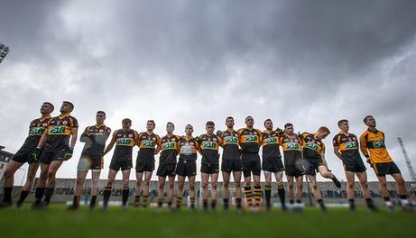
The black and amber takes to the field under the gaze of the 9,000 or so attendees.
Well done to @AustinStacksGAA today in the @Kerry_Official County Final ! Another day out required to finish the job! pic.twitter.com/VUFh4YQXK3
— John FitzGerald (@Jdbfitzgerald) October 26, 2014
The weight of history was on Stacks.
Austin stacks 20 years awaiting. 6 points up.#KeepingItTogether .. Some crowd at Kerry county final
— tadhg crowley (@docprimarycare) October 26, 2014
Confirmation it did in fact end in a draw.
FT: Austin Stacks 1-13 Mid Kerry 2-10. Draw #GAA
— John Fogarty (@JohnFogartyIrl) October 26, 2014
Sky Sports, were onto it.
Austin Stacks and Mid Kerry will replay the Kerry County Final following 1-13 to 2-10 draw. #skygaa
— Sky Sports GAA (@SkySportsGAA) October 26, 2014
The Rockie support didn’t go unnoticed either getting national attention for their antics.
The crowd in Tralee before the Kerry SFC final yesterday is why we love the GAA http://t.co/XVvTVLSrR1 pic.twitter.com/UjOieKg3st
— TheScore.ie (@thescore_ie) October 27, 2014
Austin Stacks had their own little hill 16 in the stadium today
— durkadurk (@AnaDurkan) October 26, 2014
Some handy Stats, from the match.
Austin Stacks up to the 27th minute had 9 shots and scored 1-8 pic.twitter.com/tcve4qeR0V
— Ray Boyne (@AnalysisGAA) October 26, 2014
After the match there were some fantastic photos tweeted. This one is pretty good.
Club news: Honours even today in @Kerry_Official SFC Final, as @austinstacksgaa & @midkerrygaa draw 1-13 to 2-10 #GAA pic.twitter.com/3hFd2XSfTq
— The GAA (@officialgaa) October 26, 2014
Not bad either…
#GAABEO Cluiche Ceannais Peile Chiarraí – Scór leathama @midkerrygaa 1-05 v 1-08 @AustinStacksGAA pic.twitter.com/Z8dOc0VWKx
— Spórt TG4 (@SportTG4) October 26, 2014
But, this one, might be the best.
‘Shoulder To Shoulder’ @AustinStacksGAA ahead of today’s Kerry SFC Final! @midkerrygaa @Kerry_Official @RTEgaa pic.twitter.com/X8QMlhqzhM
— Inpho Photography (@Inphosports) October 26, 2014
It’s official! We get to do all over again, which can’t be a bad thing.
The @Kerry_Official SFC Final replay between @AustinStacksGAA and @midkerrygaa takes place next Sunday: http://t.co/D4lzu81TYP #GAA
— The GAA (@officialgaa) October 28, 2014


