

.
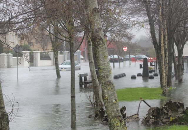
Flooding in Ballymullen back in December 2015.
FLOOD relief measures for parts of the town are still years away from being completed but the Council outlined what is intended to be done at a meeting of Tralee Municipal District last Monday.
Cllr. Mikey Sheehy had a motion before the Council that following the extended flooding in September 2016 in the Killerisk/Manor area of Tralee, he wanted to know what actions has Kerry County Council taken to mitigate against further flooding, what further works are proposed and what safeguards are in place to protect houses that were previously affected by flood water?
In reply, the Council said key staff constantly monitor river /tidal and rainfall levels for this area.
Continued below…

.
Immediately after the floods in 2016, road staff removed several trees and debris which have obstructed flow along the riparian access at Seán Crispie Park/Manor Village, however, major engineering works such as embankments need to be constructed to help mitigate high river levels in this area.
As the OPW are the leading agency for flood risk management in Ireland, they have initiated the National Catchment Flood Risk Assessment and Management (CFRAM) Programme to give a clear and comprehensive picture of flood risk.
As part of this programme, a Flood Risk Management Plan was prepared for Tralee to identify feasible structural and non-structural measures to effectively manage the assessed risk.
The particular measures being proposed for the Manor area, include:
• Construct embankments along the right bank of the River Lee and Lower Ballynabrennagh to protect properties in Manor Village, Castlemorris Mews.
• Construct embankments along the left bank of the River Lee to protect properties in the Ballymullen area including, Hunters Wood, Cois Abhann, LIDL, Topaz, Aspen Grove, Castlemaine, Glencastle.
• Construct walls along the lower Caherweesheen watercourse.
• Construct embankments and raise the N70 road further upstream on the Caherweesheen and Cloghers Stream
Continued below…

.
These works are part of an overall suite of works proposed in the Tralee scheme. The Tralee scheme, estimated at over €30m, has been included in Phase 1 of a €1billion investment proposal by OPW for the next 10 years.
As the initial scheme that went on public display, was considered at a strategic level, detailed design is now required, including detailed surveying and ground investigations, planning consent, etc.
In order to procure design consultants to carry out this detailed design, the OPW is developing template design briefs for these schemes, which will, once completed, be tailored for specific scheme areas etc.
A project team to manage the approved OPW CFRAM projects for Kerry (incl. Tralee) is currently being established.
This team will be responsible for further developing the design brief and for procuring/ appointing consultants to progress the scheme. This team will report to an OPW/KCC Steering Group.
The Council has an Emergency Response Plan for severe weather conditions, including flooding which is put into effect when there is a potential risk of flooding at various locations throughout the county, particularly where there has been a history of flooding.
However, the Council stressed that while the State, through the OPW, Local Authorities and other public bodies can take certain actions to reduce and manage the risk of flooding, individual homeowners, businesses and farmers also have a responsibility to manage the flood risk to themselves, their property and other assets to reduce damages and the risk to personal health in the event of a flood.